'Deadly Monster': Hurricane Michael has increased to Tier 3 and will hit Florida tomorrow. PHOTO, VIDEO
Hurricane Michael, which strengthened to a Category 3 today and continues to grow in strength, will hit Florida on Wednesday with "absolutely deadly" storm surge, heavy rainfall and the possibility of tornadoes that could cause more destruction than Storm Florence. Weather conditions will begin to rapidly deteriorate on Tuesday evening.

Photo: Twitter / NWS
The
In the afternoon of Tuesday afternoon, Michael’s steady winds accelerated to 120 miles per hour, which increased his category to 3 and made this spontaneous phenomenon the second largest (from 3 category and higher) hurricane of 2018 season after Florence, writes The Washington Post.
The eye of #HurricaneMichael, seen in this #GOESEast loop cat. 2 storm moves north over the eastern Gulf of Mexico. Follow Michael on our Atlantic hurricane tracker: https://t.co/d4YBBwPJah pic.twitter.com/qEtcC70zoh
- NOAA Satellites (@NOAASatellites) October 9, 2018
Hurricane #Michaelseen here by #GOESEastis strengthening the gulf of Mexico. The center of the Cat. 2 storm is expected to move inland over the Florida Panhandle on Wednesday. Latest: https://t.co/ZrHnIiaJs1 pic.twitter.com/8oMdOx2YVv
- NOAA Satellites (@NOAASatellites) October 9, 2018
Today, Gov. Rick Scott warned that Hurricane Michael is predicted to be "the most devastating storm that will hit the Florida Panhandle in the last few decades."
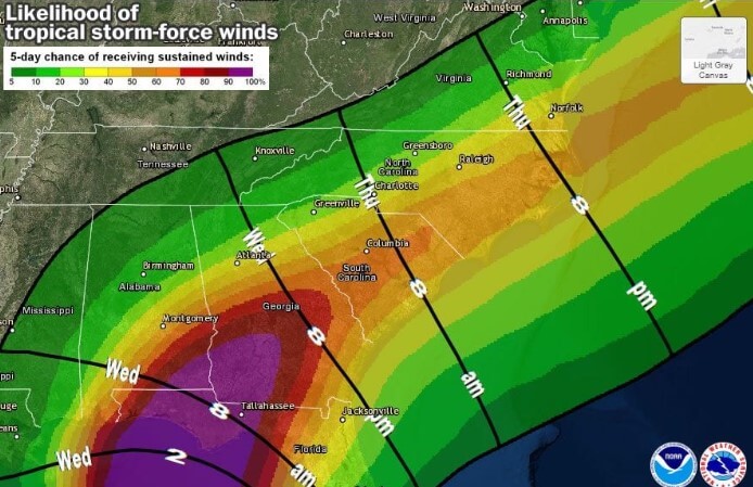
Photo: National Hurricane Center
“A potentially catastrophic event is developing,” wrote the National Weather Service office serving Tallahassee and surrounding areas. Forecasters warned of "widespread power outages, downed trees blocking access to roads and putting people in danger, structural damage to homes and businesses, isolated flash flooding and the potential for several tornadoes to develop."
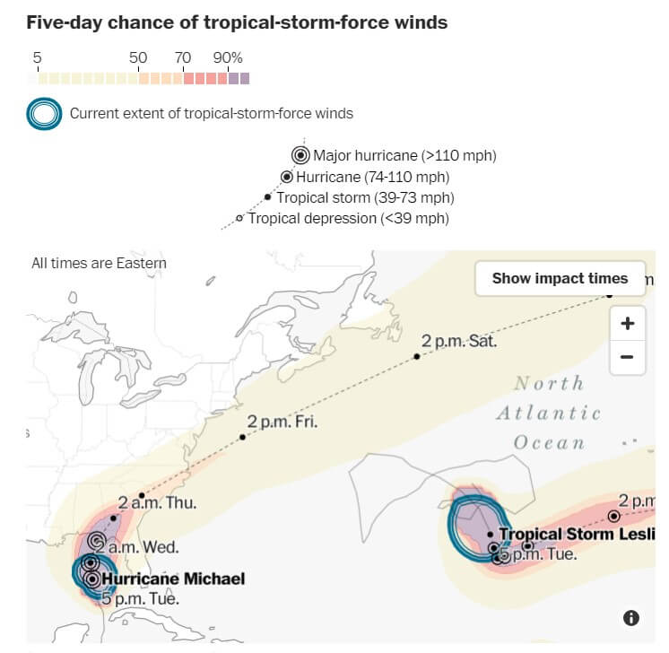
Photo: National Weather Service
According to a forecast by the National Meteorological Service, it is expected that the storm will move across the eastern Gulf of Mexico on Tuesday and come ashore at Panhandle on Wednesday afternoon.
#AnnaMariaIsland flooding as #hurricanemicheal approaches off shore (by Carol). Zero rain today. @spann @bn9weather pic.twitter.com/IbTWqy3U1K
- ThingsmyMomsays (@ thingsmymomsay1) October 9, 2018
Hurricane winds are raging 45 miles from the center of the storm, according to meteorologists. According to them, partly hurricane will go deep into the mainland. FEMA spokesman Jeff Byard said that Hurricane Michael could deal a greater blow than the destruction that the tropical storm Florence brought.
Waves from #hurricanemicheal along the beach in Panama City Beach, Florida – Video Credit: Gary Schmitt / LSM pic.twitter.com/aRvLra2GC3
- ABC 33/40 News (@ abc3340) October 9, 2018
On Tuesday morning, Governor Scott called for residents to evacuate, warning that the disaster would begin its destructive effect on the region long before going ashore.
It's getting a little wet out here #hurricanemicheal #wtxltrackingmichael pic.twitter.com/QvpZ3UQssr
- WTXL ABC 27 (@ abc27) October 9, 2018
“Hurricane Michael is a monster storm. The forecast is becoming increasingly dangerous,” the governor said. He added that the biggest concern is the "absolutely deadly" storm surges of 8 to 12 feet expected even offshore. Scott said water would enter the mainland and travel for miles along the coastline and "could easily end up over rooftops."
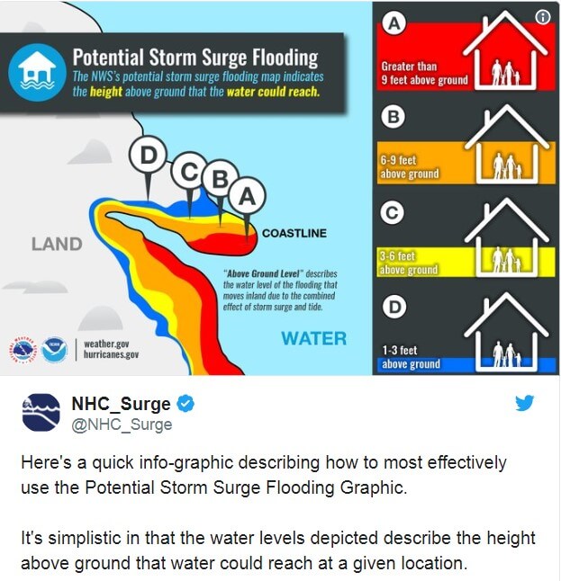
“You can't shelter from storm surges, so prepare and get out,” he said. “Remember, we can rebuild your home, but we cannot rebuild your life.”
#hurricanemicheal how a major category 3 hurricane. Heading towards the gulf coasts! #FLwx #Micheal #USA pic.twitter.com/AAer2bOr82
- WEATHER / METEO WORLD (@StormchaserUKEU) October 9, 2018
In coastal areas, mandatory evacuations continue, where 1250 National Guard soldiers are helping this process, and more 4000 troops are on standby.
On Monday, Scott asked President Donald Trump to declare a state of emergency and declared a state of emergency in 35 districts. Trump signed the order on Tuesday.

Panhandle, from Pensacola to Apalachicola and the Big Bend area, is the area of greatest alertness. Storm surges here can flood more than 325 miles of shoreline. The hurricane will also bring devastating winds and floods throughout the environment.
By Friday, Panhandle and Big Bend in Florida, southeastern Alabama and southern Georgia are expecting 4-8 inches of rain, and in some parts of these regions a foot can be observed. In North and South Carolina, which have not yet recovered from Hurricane Florence, as well as in eastern Georgia and southern Virginia, rainfall can be from 3 to 6 inches.
Read also on ForumDaily:
'Leave Before It's Too Late': Mass Evacuations Begun due to Hurricane Michael
Americans warned: 12 years left before dangerous climate change
The hurricane carries a powerful wind and flood in Florida
Hurricane Sergio carries abnormally high waves to California
Subscribe to ForumDaily on Google NewsDo you want more important and interesting news about life in the USA and immigration to America? — support us donate! Also subscribe to our page Facebook. Select the “Priority in display” option and read us first. Also, don't forget to subscribe to our РєР ° РЅР ° Р »РІ Telegram and Instagram- there is a lot of interesting things there. And join thousands of readers ForumDaily New York — there you will find a lot of interesting and positive information about life in the metropolis.


-
What to do if you have lost your confirmation number for the green card lottery2142
-
Pension in the USA: a complete guide on how to secure a decent old age in America2094
-
Nine charming castles in the USA, which can be viewed both from the outside and from the inside491
-
How to Recognize Immigration Fraud and Protect Yourself: USCIS Recommendations117
-
May the 4th be with you: 10 Interesting Star Wars Facts45
-
Expert Tips: Effective Mosquito and Tick Protection Methods10
-
What Supplements Do Longevity Experts Take to Stay Young?0
-
Pros and cons of political asylum in the United States12868
-
Personal experience: who and why you should not move to the USA5614
-
Where in the USA to buy the medicines we are used to: a list of pharmacies5330
-
50 diseases whose presence will increase the cost of health insurance in the USA4329
-
Five dangerous mistakes when applying for a green card due to marriage4147
-
What to do if you have lost your confirmation number for the green card lottery2142
-
Pension in the USA: a complete guide on how to secure a decent old age in America2094