Google will help New Yorkers find out if the bus or subway car they are going to be on is full
Google wants to make it easier for New Yorkers to travel by public transport.

Фото: Depositphotos
The Google Maps application will now make predictions about the workload of some subway lines and buses in New York. The city has become one of the almost 200 megacities of the world, for which since June 27 this function became available, writes AMNY.
The forecasts are based on Google surveys conducted in the past among public transport passengers who used the app to determine the route. Passengers were polled on different lines and at different times of the day, so Google now has averaged data on traffic on different days and at different times.
On the subject: Instead of MetroCard: New York Metro Launched Fare
“We're introducing city traffic congestion forecasts so you can see how many people are currently using the bus, train or subway you want to use. This data will be based on past trips. Now you can make an informed decision about whether you want to try to squeeze into the crowd of passengers, or wait a few more minutes until you have a better chance of riding while sitting,” Google Maps said.
It remains to be seen how useful this function will be in New York, where public transport is usually much cheaper than taxis and similar services. Currently, the MTA is working to create a similar function for express buses, which will allow passengers to see how many free seats are available on each such bus.
New update Google Maps, which appeared 27 June, also contains information about the delays of buses in real time. MTA already offers this information on its website and on social networks.
On the subject: Study: a trip to the subway in New York may increase the risk of cancer
Google didn’t respond to a query about which metro lines and bus routes will be available to check for workload. A company spokesman said only that the forecasts would be available on all lines where enough data was collected to make accurate predictions.
Google accompanied the release of the new feature by publishing a ranking of the busiest train lines in the world, based on user survey data. New York City subway riders may be surprised to learn that their city didn't top the list. Only one MTA line, the L, ranked among the top 10 busiest train lines in the world, coming in last, XNUMXth.
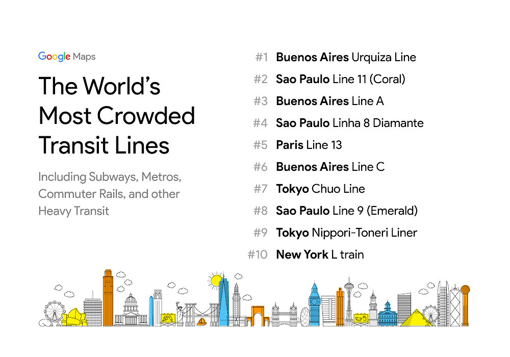
Infographics: blog.google
Read also on ForumDaily:
How Google listens to you through the microphone and where to find these recordings.
How to upload a copy of everything Google knows about you
Big Brother: how to prevent Google from collecting information about your movements
Subscribe to ForumDaily on Google NewsDo you want more important and interesting news about life in the USA and immigration to America? — support us donate! Also subscribe to our page Facebook. Select the “Priority in display” option and read us first. Also, don't forget to subscribe to our РєР ° РЅР ° Р »РІ Telegram and Instagram- there is a lot of interesting things there. And join thousands of readers ForumDaily New York — there you will find a lot of interesting and positive information about life in the metropolis.


-
What to do if you have lost your confirmation number for the green card lottery2142
-
Pension in the USA: a complete guide on how to secure a decent old age in America2094
-
Nine charming castles in the USA, which can be viewed both from the outside and from the inside491
-
How to Recognize Immigration Fraud and Protect Yourself: USCIS Recommendations117
-
May the 4th be with you: 10 Interesting Star Wars Facts45
-
Expert Tips: Effective Mosquito and Tick Protection Methods10
-
What Supplements Do Longevity Experts Take to Stay Young?0
-
Pros and cons of political asylum in the United States12868
-
Personal experience: who and why you should not move to the USA5614
-
Where in the USA to buy the medicines we are used to: a list of pharmacies5330
-
50 diseases whose presence will increase the cost of health insurance in the USA4329
-
Five dangerous mistakes when applying for a green card due to marriage4147
-
What to do if you have lost your confirmation number for the green card lottery2142
-
Pension in the USA: a complete guide on how to secure a decent old age in America2094